WHAT AM I GOING TO LEARN?
1.The water cycle
2.Groundwater, glaciers and icebergs
3.Erosion. Rivers, oceans and seas
WHAT DO I HAVE TO STUDY?
-Unit from your book.
-English handouts and worksheets.
-Spanish and English vocabulary (use your glossary book and vocabulary organizer).
-Activities from your book.
-The outline you made.
THE WATER
This unit is all about water. Water covers 71% of the Earth’s surface. That seems a lot, but we can only drink or irrigate crops with fresh water (water without salt). Almost all of the water in the world is salt water in the seas and oceans. Almost all of the fresh water is stored, either as ice or underground. The rest of it is constantly flowing from one place to another, round the water cycle.

1.1 Water cycle
Water is constantly flowing round the water cycle
1. EVAPORATION: Water evaporates from the sea to form water vapour, but the salt stays behind. This means that water vapor is fresh water.
2. CONDENSATION: The water vapor rises and condenses to form clouds
3. WIND: The wind blows the clouds towards the land
4. PRECIPITATION: Water falls as rain, snow or hail
5. INFILTRATION: Some of the water filters into the ground and through to the sea
6. RIVERS: The rest of the water drains into the rivers and then flows into the sea

1.2 Groundwater
Groundwater is underground water. About 30% of the Earth’s fresh water is groundwater.
•When it rains, some of the water filters into the ground. The water passes through porous rocks until it gets to a layer of impermeable rock and cannot go through any further.
•It stays in the porous rock in an aquifer. An aquifer is a layer of porous rock that stores water.
•Aquifers provide a lot of our drinking water. People dig wells to get the water out. A spring is where water from an aquifer flows out at the surface.

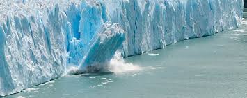
2. Icebergs and glaciers
Over two-thirds of the fresh water on Earth is frozen, so it is actually ice. Glaciers form on land from fallen snow, which gradually turns into ice. – Most of the glaciers on Earth are in polar regions like the Antactic and Greenland – There are also glaciers in high mountain areas which are like rivers of ice that move downhill very slowly When glaciers reach the sea, pieces break off to form iceberg. Icebergs are blocks of ice floating in the sea.


3. EROSION
Water is one of the main causes of erosion. Rivers and the sea both cause erosion. There are three stages:
– WEATHERING: the water wears away rock and soil
– TRANSPORT: the river or sea takes away the pieces of rock and soil (called sediments)
– DEPOSITION: the river or sea leaves the sediments in a different place Weathering and erosion can also happen when:
– Glaciers int the mountains move gradually downhill, taking pieces of rock with them
– The wind moves sand and soil (this often happens in deserts)
– Temperature changes make rocks crack into pieces
– Animals dig up the soil
Plantas can cause erosion if they grow in cracks in rocks, but normally plants help to hold the soil together and prevent erosion. Humans can also cause erosion.


4. RIVERS
The drainage basin of a river is the area where water from rain and snow trains into the river
•A tributary is another river that flows into the main river
•The place where two rivers meet is called the confluence
•The course of a river is the route it follows from the source to the mouth
•The course is divided into the upper course, middle course, and lower course
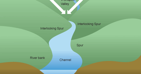
4.1 Upper course
The upper course is the first part of the river, nearest the source. The upper course is steep and the river flows fast.
•In the upper course, the river erodes the rock and soil to form valleys and canyons. The river takes away the sediments.
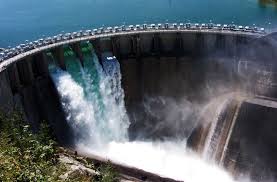
Some people call Great Falls the “Electric City” because there are lots of hydropower stations. Hydropower stations produce electricity using the force of falling water. The water is stored in reservoirs. Reservoirs are artificial lakes formed by dams. The water stored in reservoirs is used for drinking, industry and agriculture. Dams are walls that hold water in reservoirs. They help to control the level of water in the river and prevent flooding.
4.2. MIDDLE COURSE
The middle course is the middle part of the river. The river becomes less steep, and the valley is wider. The water runs more slowly.
•In the middle course, the river starts to bend. Bends in a river are called meanders.

4.3 Lower course
The lower course is the part of the river nearest the mouth. The river becomes very flat and wide, so big ships can travel along it. TheMissouri and Mississippi are important transport routes.
•The river here often floods. The floodplain is the area of the valley that is flooded.
•The river moves very slowly, so it leaves the sediments that it is carrying on the floodplain. The sediments form fertile soil, so the floodplain is a good place to grow crops.
•A delta form is a lot of sediment builds up near the mouth of a river. In a delta, the river divides into lots of smaller channels.
•The area where fresh water and salt water mix at the mouth of a river is called the estuary.

5. SEAS AND OCEANS
•The seas and oceans contain almost all of the Earth’s water. Water in a sea or ocean is called seawater or salt water, because it contains a lot of salt. The amount of salt depends on the temperature.
•If it is hotter, more water evaporates, so a higher concentration os salt is left.
•The high salt level makes it very easy to float in the Dead Sea.
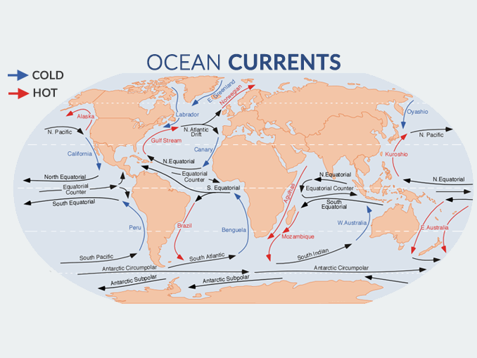
5.1 Ocean Currents
•Ocean currents are huge movements of water in the oceans
•Warm currents are warmer than the surrounding water because they start in warmer places
•Cold currents are colder than the surrounding water because they start in colder places
•Ocean currents can make the climate warmer or colder.
5.2 Waves
The wind produces waves on the surface of the water.
•Surfers talk about “riding a wave” but waves don’t really move forward. They go up and down in a circular motion.
Waves cause coastal erosion, which gradually changes the shape of the coastline. Beaches form in areas where sediment builds up.
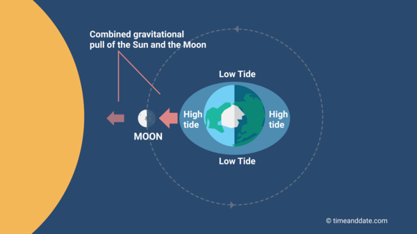
TIDES:
•Every day the level of the sea rises and falls because of the gravitational pull of the moon.
•The highest level is called high tide and the lowest level is called low tide.

Vocabulary Unit 3
- Water Cycle : It is the process when the water changes its physical state.
- Fresh water : It is the water found in rivers, lakes, glaciers, groundwater and at the poles.
- Groundwater : It is the water run and is scored under the ground.
- Flow : It is the amount of water it carries
- Basin : It is the area occupied by a river and its tributaries.
- Tributaries : It is smaller rivers flowing into a large river.
- Source : It is the place of a river starts.
- Glaciers : They are masses of ice created by the accumulation of snow.
- Lakes : They are permanent masses of water which have accumulated inland.
- Wadis : They are basins in the desert.
- Rivers : They are permanent currents of water
- Canals : It is build by human beings, and used to transport water.
- Reservoirs : They are artificial lakes to store water.
- Water supply : It is the water in reservoirs and is offered to people and industries.
- Dams : They are build of human beings used to produce electricity.
- Hydroelectric power station : It is a station used to produced electricity through the water.
- Salinity : It is the amount of salt with containing the oceans and seas.
- Warm current : These currents are produced when the temperature of a current is higher than the water around it.
- Cold current : These currents are produced when the temperature of a current is colder than the water around it.
- Tides : They are the diary rise and fall of the water level. They are caused by the gravitational forces of the Moon and the Sun.
- Waves : They are undulations of the surface of the water produced by wind.
- High tide : This tide is produced when rise the level of sea.
- Low tide : This tide is produced when falls the level of sea.
- Lagoons : It is smaller lakes.
- Inland seas : It is a saltwater lake.
- Ocean currents : They are large masses of water, similar to rivers, which circulate through oceans.
- Aquifers : It is forms when the water can´t pass through the impermeable rocks
- Springs : It is forms when groundwater finds a way to the surface. They can be cold or hold water.
- Drinking water : It is the water you can drink. Groundwater is valuable because there are drinking water.
- Icebergs : It is a floating mass of ice.
- Consumption : It is the fresh water which use the human being for life. It is only 0.014%.
- Droughts : It is shortage of water.
- Floods : It is excess of water
- Water Pollution : It is large amount of materials are added to a body of water.
Acid rain: It contains harmful chemicals such as sulfur and nitrogen. These chemicals are released into the atmosphere as gases.
