WHAT AM I GOING TO LEARN?
1.The atmosphere.
2. Water and climate.
3. The elements of climate: temperature, precipitation, atmospheric pressure and wind.
4. The Earth’s climates.
5. The natural environment.6. Atmospheric phenomena and natural hazards.
WHAT DO I HAVE TO STUDY?
●Unit from your book.
● English handouts and worksheets.
● Spanish and English vocabulary (use your glossary book and vocabulary organizer)
●Activities from your book.
● The outline you made.

Planet Earth is surrounded by a gaseous layer called the atmosphere. This wrapping makes the existence of life on our planet possible.
The atmosphere is composed of a series of gases
The Nitrogen (78%) and the oxygen (21%) are principal elements. Gravity makes it possible for the majority of these gaseous components to stay in the lower zones.
The atmosphere is divided into layers
Each one with different characteristics. These are Troposphere, Stratosphere, Mesosphere, Thermosphere (or Ionosphere) and Exosphere. The closest layer, the Troposphere, is that which presents the principal phenomenon that which give rise to the different types of weather.
•Troposphere – The closest layer to the Earth – Meteorological phenomena take place here – The greenhouse effect – 80% of the gases are in this layer.
• Stratosphere – It contains the ozone layer
• Mesosphere – Falling stars form here
• Ionosphere or Termosphere – Aurora borealis and aurora australis (Northern and Southern lights) are produced here
• Exosphere – The last layer – Very very few air molecules in this layer – No clear boundary between this layer and space
1 Atmospheric pressure
The atmosphere is a layer of gases (mainly nitrogen and oxygen) that surrounds the Earth. We call this mix of gases air. The atmosphere regulates the temperature:
– it stops it getting too cold at night
– when air moves it spreads the heat from hot zones to colder parts of Earth Atmospheric pressure is the weight of the air above the Earth’s surface At higher altitudes there is less air above us, so the pressure is lower

Warm air is lighter than cold air, so warm air always rises above cold air. Areas of high pressure are called anticyclones. They normally bring clear, stable weather. Areas of low pressure are called depressions. They often bring unstable weather, like rain and storms. Pressure differences also cause wind. Weather maps show areas of higher pressure and lower pressure. The lines on the map connect places with the same pressure
– they are called isobars.
– We measure atmospheric pressure with a barometer
– The units of measurement are millibars (mb).
1.2 Temperature
The temperature is the amount of heat in the atmosphere
LATITUDE:
Temperatures vary with latitude: they are highest near the equator and lowest near the poles. The Earth is divided into five climatic zones.
THE HOT ZONE OR TROPICS
Between the Tropic of Cancer and the Tropic of Capricorn. The sun’s rays cover a small area all year round, so the sun’s heat is concentrated and it is always hot.
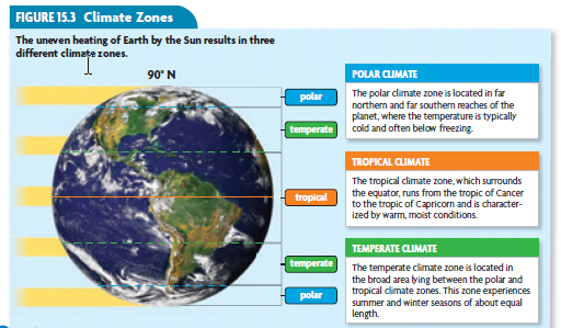
TWO TEMPERATE ZONES:
Between the Tropic of Cancer and the Arctic Circle and between the Tropic of Capricorn and the Antarctic Circle. The sun’s rays are spread over a larger area, so it is not as hot as the hot zone. There are seasons: it is warmer in the summer than in the winter.
TWO COLD ZONES:
Inside the Arctic and Antarctic Circles. The sun’s rays are spread over a very large area, so they don’t give much heat. It is always cold here.
ALTITUDE: Temperatures are usually warmest at low altitudes and get colder as we go higher
DISTANCE FROM THE SEA: The sea moderates temperatures: – In summer, the sea takes longer to heat up than the land. This means that coastal areas are less hot in summer than places further from the sea. In winter the sea takes longer to cool down than the land. This means that coastal areas are less cold in winter than places further from the sea. We measure temperatures with a thermometer. The unit of measurement is degrees Celsius (ºC). Some people say degrees centigrade, but is the same as degrees Celsius.
2. Movement of the Earth
The Earth rotates on its axis once a day, so it does one complete rotation every 24 hours. As the Earth rotates, places on the surface sometimes face the sun – this is day. When they face away from the sun, it is night. The Earth orbits around the sun every 365 1/4 days, or once a year. Each year has four seasons (spring, summer, autumn and winter). There are seasons because the Earth’s axis is not vertical. It is tilted.

NORTHERN HEMISPHERE SUMMER
In summer, the Northern Hemisphere is tilted towards the sun. The northern temperate zone spends more time facing the sun than facing away from the sun, so days are longer than nights. The sun’s rays cover a small area, so the sun’s energy is concentrated and it is warm.
NORTHERN HEMISPHERE WINTER
In winter, the Northern Hemisphere is tilted away from the Sun. The northern temperate zone spends more time facing away from the sun than facing the sun, so nights are longer than days. The sun’s rays are spread out over a larger area, so the sun’s energy is less concentrated and it is cold.
In the cold zones, there is a bigger difference between summer and winter: in the middle of winter, the night lasts for 24 hours (so it is always night), and it is very cold. In the middle of summer it is always day, so it is less cold. Even so, the sun’s rays are still spread out, and it is colder than in other areas. In the hot zone, near the equator, the tilt of the Earth does not make much difference. The sun’s rays always cover a small area and it is always hot. There is no winter and summer.
3. PRECIPITATION
Precipitation can be rain, snow, sleet or hail. What happens when it rains? There are actually three types of rainfall.
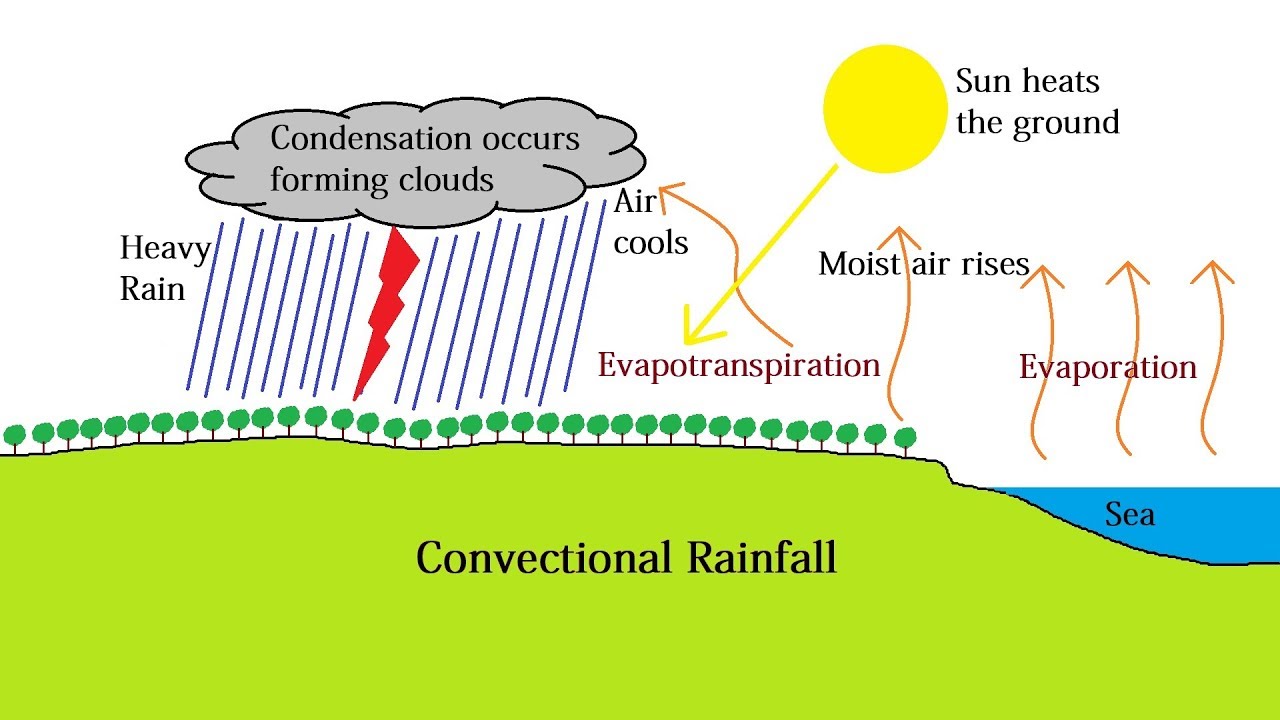
CONVECTIONAL RAINFALL
This is common in hot, humid places, especially in the tropics. The sun heats the ground, and water evaporates to form water vapour. The warm air rises, taking the water vapor with it. When it rises, the pressure falls. As the air rises, it cools, and the water vapor condenses (this means it turns into small droplets of water). The droplets of water form clouds. The water droplets grow until they become so heavy that they fall as rain.
FRONTAL RAINFALL
A front is a boundary between masses of warm, humid air and cold air. Frontal rainfall occurs where warm air meets cold air. The warm air rises, and is pushed above the cold air. When the air rises it cools, the water vapor condenses, and it rains.

RELIEF RAINFALL
This is common in areas with hills and mountains. The wind blows warm, humid air in from the sea. The air has to rise to get over the mountain. The air cools, so the water vapor condenses, and it rains. Usually, all the rain falls on the side facing the sea. Much less rain falls on the far side.

We measure the amount of rain using a rain gauge (mm) or litres per square metre (l/m2).
4. WIND
Wind is the movement of air. It always goes from areas of higher pressure to areas of lower pressure.
•PREVAILING WINDS: Some winds always blow in the same direction. These are called prevailing winds. For example, the trade winds always blow from the tropics towards the equator.
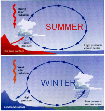
•SEASONAL WINDS: Monsoons in Asia are seasonal winds. That means they change direction at different times of year.
DAILY PATTERN:
Some winds change direction on a daily basis. A sea breeze blows from the sea to the land during the day and then the direction changes and a land breeze blows from the land to the sea at night.
•LOCAL WINDS: Other winds don’t have a regular pattern. These are called local winds. One example is the levante in the Mediterranean.
•Wind speed is measured with an anemometer. The unit of measurement is kilometres per hour (Km/h). Wind direction is measured using a weather vane.
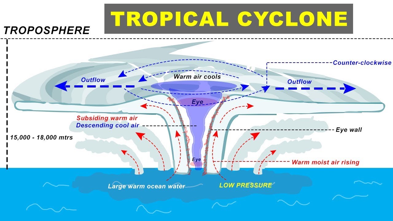
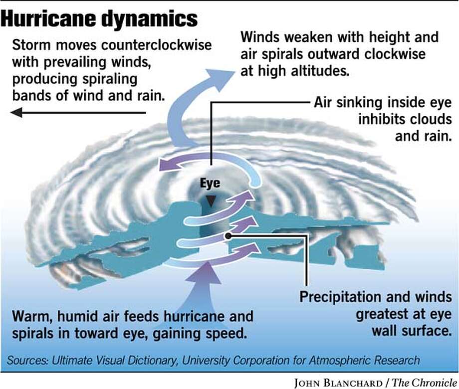
4.1 Tropical Cyclones
•In a storm there are strong winds, heavy rain and sometimes thunder and lightning. •Tropical cyclones are very big storms that form in the tropics. Hurricanes and typhoons are two alternative names for very powerful tropical cyclones
•Tropical cyclones have a spiral shape and can be hundreds of kilometres wide
•The centre of the cyclone is called the eye, and it is typically about 50 km wide. In the eye there are no clouds and there is not much wind
•Tropical cyclones form over warm seas (more than 26ºC) where there is a lot of evaporation. When the water vapor condenses, it releases huge amounts of energy. This is why tropical cyclones are so powerful and destructive.
•They lose strength when they move over land, so they are mainly a problem in coastal areas.
5. Floods
If it rains a lot in a short time, the ground cannot absorb all the water, and we get flooding. Floods can wash away people and things, damage or destroy houses and other buildings, destroy crops, spread diseases like cholera and typhus. Humans often make the effects of flooding worse: – they build towns too close to rivers – roads and buildings are impermeable so they stop the ground absorbing the water – they cut down trees (trees take water out of the ground so cutting them down reduces the amount of water that it can absorb).

6. Drought
A drought is a long period with less rain than usual for the area. The definition of a drought therefore varies from country to country. Some effects of droughts are:
– low water supplies
– crop failure – vegetation gries out, making wildfires more likely. Woldfires are fires that are out of control soil erosion, because there is less vegetation to hold the soil together Drought is usually more serious in poorer countries. If people don’t have enough money to buy food when their crops fail, they may die.

4. CLIMATES, VEGETATION AND BIOCLIMATES
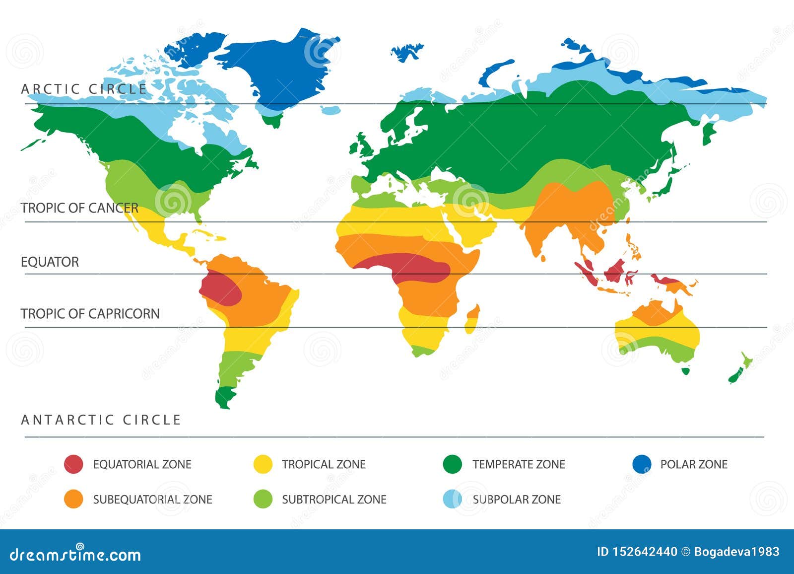
The combination of the temperature, precipitation, atmospheric pressure and wind creates the different climatic zones. A climatic zone is a division of the climate of the Earth according to average temperatures and average rainfall (precipitation level). We can distinguish the following climatic zones:
–Torrid zone, which includes the equatorial and tropical climates
-The northern and southern temperate zones, which includes the mediterranean, oceanic and continental climates
-The northern and southern frigid zones which includes the polar climates
Also appear azonal climates that can be found in different regions: deserts and mountains.
Vegetation and biosphere
Vegetation: is the entire range of plant life in an área. It is a part of the biosphere
Biosphere: is the combination of all living beings on the planet and the enviroment they live in. It is formed by the troposphere, the Hydrosphere and the litosphere.
The main characteristic of the biosphere is its enormous diversity of plant and animal species (biodiversity). Plants are organised in vegetal formations.
A vegetal formation is the combination of plants in a región that are similar in size of characteristics. We can distinguish three types of vegetal formations:
-Forest areas are formed by trees. A tree is a plant which has a clearly defined trunk and is tall (usually more than 8 metres of height).
-Scrubland consist of bushes. Bushes are smaller than trees and have not trunk. Its branches divide at ground level.
-Grasslands consists of grasses.
The distribution of the vegetation is conditioned by numerous factors:
-the relief
-the soil
-the climate (humidity, light, temperatura and wind).
The Earth’s bioclimates
Earth is divided in several bioclimatic enviorments or bioclimates. A bioclimate is a extensive región characterised by its own climatic features and vegetation. We can distinguish three major bioclimates.
-the torrid bioclimate.
-the temperate bioclimate.
-the frigid bioclimate.

Vocabulary. Unit 4
Weather: It refers to the state of the atmosphere in a place at a specific time.
Climate: It refers to the state of the atmosphere in a place over a long period of time.
Weather station: The place where it studies the weather and climate.
Axis: It is the point where the Earth rotates.
Orbits: It is the way that follows the Earth in her revolution around the Sun.
Cold zone: It is the zone whithin the polar circle. In this area, the temperatures are always cold.
Latitude: It consists that the areas near the Equator rain more than the other areas.
Altitude:It consists that it rains more in high areas than in low areas.
Inland climates: It is a climate which is much hotter in summer and much colder in winter.
Humidity: It is amount of water vapor in the air.
Anticyclones: It is areas with a high pressure.
Depressions: It is areas with a low pressure.
Anticlockwise: It is the opposite sense to the clock wise.
Average temperature: It is the average of the temperatures in an area.
Maximum temperature: It is the highest temperature of an area.
Minimum temperature: It is the lowest temperature in an area.
Jet Stream: It is a wind that blows from east to west and it is found in the temperate zones.
Global wind patterns: It is the group of every winds on the Earth.
Doldrums: It is a place where the wind don’t blow
Sea breeze: It is a type of synoptic winds which is blowing from the sea towards the land by day.
Rotation: It is when the Earth spins on a imaginary straight line called axis.
Revolution around the Sun: It is the movement of the Earth around the Sun. That produces the year and the seasons.
Equinoxes: It is the moment that mark the beginning of Autumn and spring
Solstices: It is the moment that mark the beginning of winter and summer.
Thermometer: It is the tool necessary to measured the temperature.
Hot zone:It is the zone where the Sun’s rays reach the earth in perpendicular angle all year round, so temperatures are always high.
Temperate zone: It is the zone between the tropics and polar circle. In this area the temperatures are temperate.
Precipitation:It is droplets that fall on the Earth’s surface.
Convectional rain: This is a type of rainfall characteristic of hot climates.
Orographic/ Relief rain: This is a type of rainfall characteristic of mountains regions.
Frontal rain: This is a type of rainfall takes place at the boundary, between a mass of warm air and a mass of cold air.
Front: It is the boundary between different air masses.
Atmospheric pressure: It is the force exerted at a specific point on the Earth´s surface by the weight of the air above it.
Prevailing winds: These winds always blow in the same direction.
Periodic winds: These winds change direction seasonally.
Seasons:Different moments around the year when temperatures and rainfalls change. It are produced with the orbit of the Earth.
Synoptic winds: These winds change daily.
Trade wind: These are winds influenced by the surrounding geography.
Water vapor: It is the water evaporated.
Land breeze: It is a type of breeze given in the land.
